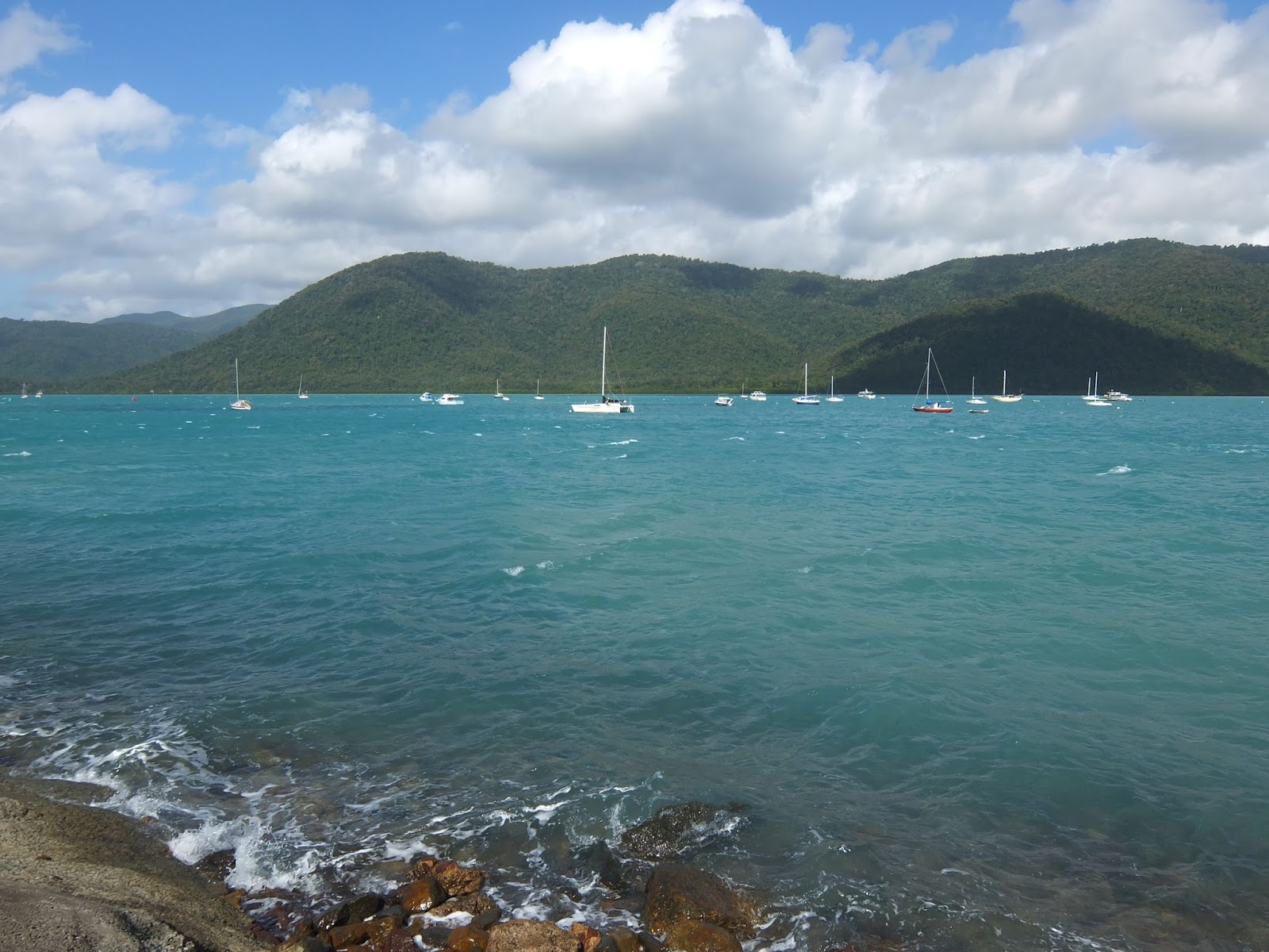
A little over 4 years after leaving Apollo Bay to drive Great Ocean Road with Tiia, I returned in the dead of winter with Mom and Dad. On the Solway Lass there was a couple from Melbourne who had said the city was experiencing a mild winter, so we were hoping for cool, sunny days. Flying from Hamilton Island, we arrived after lunch to grey skies and rain. We found our rental car and with Dad as navigator and me in the driver's seat, we managed to successfully exit the airport and find our way onto the Princes Freeway. We decided to stop for lunch in Geelong before continuing to Torquay, the official start of Great Ocean Road. Unfortunately it continued to rain steadily all afternoon, which made our drive not as scenic as I had thought it would be. I had been on this stretch of Victorian coastline several times before and loved it, but I was sad that Mom and Dad were missing out. I insisted we get out for the photo opportunity under the Memorial Archway, built as a tribute to soldiers from the First World War. We then continued on to Lorne, where we stopped to pick up some groceries before driving the final 43 kilometres to Apollo Bay in the dark. We were almost home.
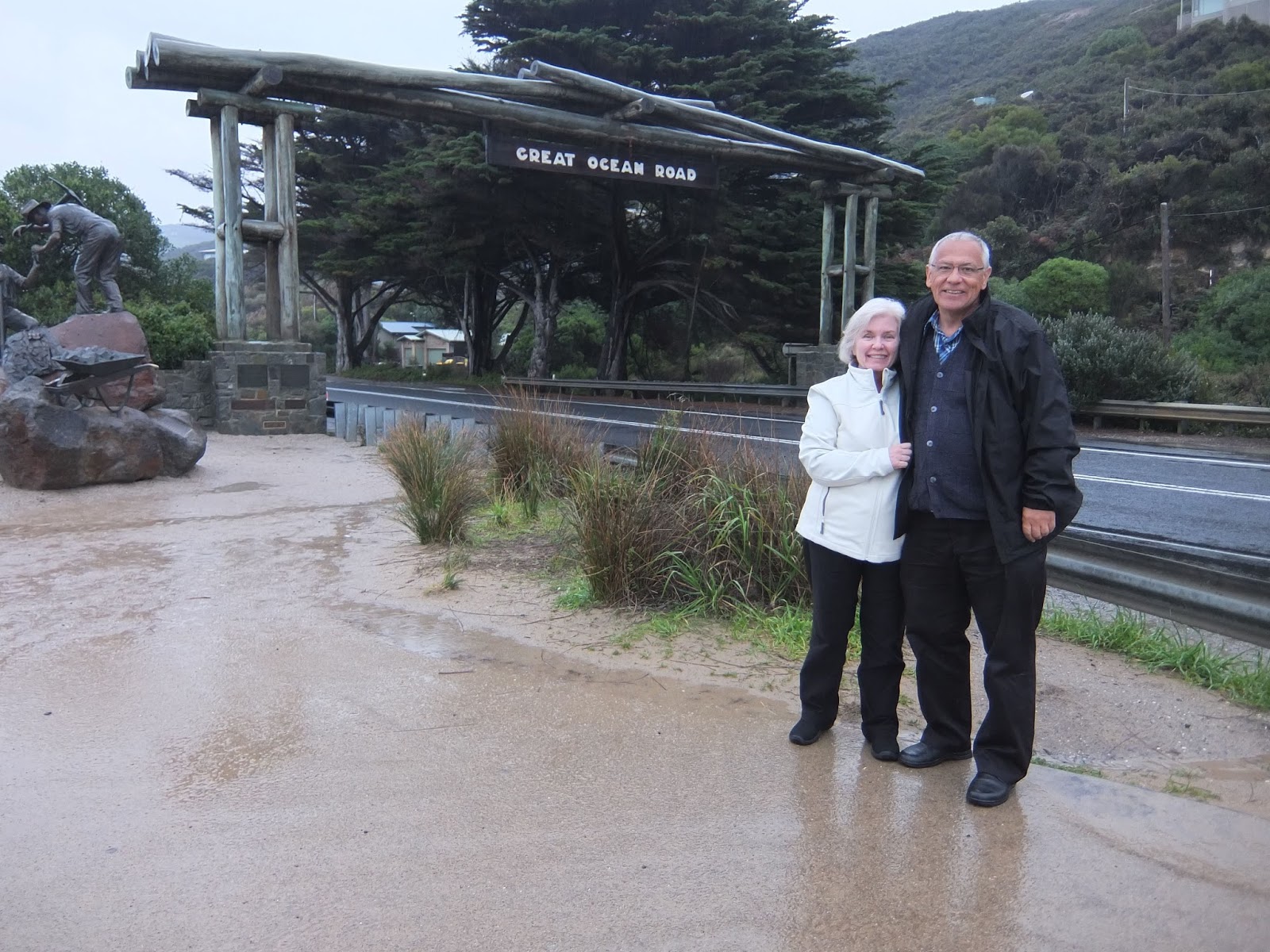
Hurry up and take the picture! We're getting wet!
The next day we left just after 8am, heading west toward the Twelve Apostles, the most well known stop along Great Ocean Road. The rain had stopped, but it was still clouded over and quite windy. We bypassed the Cape Otway Lighthouse (we would return the next day) and continued on to the Visitor Information Centre at Port Campbell National Park. This is where all the tourists were. There were hundreds of people stopping to view the Twelve Apostles, a collection of limestone stacks just off the shore. Originally there were 8 stacks (there never were 12, despite the name), but in July, 2005, a 50 metre stack collapsed into the sea, leaving only 7. They were still formidable, however many there were.

The Twelve Apostles. In the foreground,
you can see the remains of the stack that fell in 2005.

 Love these signs!
you can see the remains of the stack that fell in 2005.

Dressed for the weather. The high for the
day was around 14 degrees Celsius.
After taking lots of photos, we hopped back into the car and continued west a couple of kilometres to the next stop, Loch Ard Gorge. The gorge is named after the clipper ship Loch Ard that ran aground on a reef on June 1, 1878. This part of the Australian coastline, from Cape Otway to Moonlight Head, is known as Shipwreck Coast as approximately 638 ships met their fate here. At this stop, you could also see Mutton Bird Island, the Thunder Cave and the Blowholes. I liked Thunder Cave, which I think must have been louder than usual as the wind had picked up and the sea was quite rough. When Tiia and I had visited the first time, it was a blowing a gale and pouring rain. We got soaked running from site to site, taking photos while trying to keep our cameras dry. This time it didn't rain much, but it did threaten and it was quite windy. Gil said his favourite time to see the Twelve Apostles was when it was stormy and the sea was raging, and I have to agree that it's quite picturesque. It's also beautiful during sunset, which Tiia and I had the second time we visited, five days later. We didn't get much of a sunset this time around as there was too much cloud.

Continuing west a few kilometres, our next stop was the Arch.

Another couple of kilometres down the road, was London Arch and the Grotto. London Arch used to be known as London Bridge, as it was a complete double span natural bridge until January 15, 1990, when the part closest to the shore collapsed, stranding two tourists who then had to be rescued by helicopter. No one was hurt when it happened, which is quite amazing.

 How many koalas can you spot?


Loch Ard Gorge
Continuing west a few kilometres, our next stop was the Arch.

Another couple of kilometres down the road, was London Arch and the Grotto. London Arch used to be known as London Bridge, as it was a complete double span natural bridge until January 15, 1990, when the part closest to the shore collapsed, stranding two tourists who then had to be rescued by helicopter. No one was hurt when it happened, which is quite amazing.

London Arch
 The Grotto

Driving through Peterborough, we turned around at Bay of Islands, which was lovely. No other tourists had ventured this far at that time, so we had the place to ourselves. I didn't get any good shots at the beach, however, as we had lost what little light we had had earlier and most of my pictures are quite dark. Heading back toward Apollo Bay, we stopped at the Twelve Apostles again, hoping to get a sunset shot, but it was too cloudy. It was time to head back. I love driving Great Ocean Road. It's very windy and hilly, and you never know what's around the corner. It was getting dark and foggy, and I knew kangaroos might be out and about, but I still enjoyed it. Beats driving down to Calgary or Coral Bay any day.


Our wheels (beats my Holden Astra,
but I wish we had hired a sports car...)
The next day I drove Mom and Dad up to Marriners Lookout. When I lived in Apollo Bay I used to walk most mornings from the hostel to the base of Marriners Lookout Road, climb up to the top, admire the view and walk back down in time to start work at 10am (check-out time). All up I think it took close to 90 minutes and I loved it. When I wasn't walking the hill, I was walking along the beach, which was mostly deserted at that time of day. We parked at the top and walked the final 15 minutes to the viewpoint. Saw lots of sheep, but no baby goats (there were two the summer I was here). The sun had come out and we were rewarded with a great view.


We headed back out west, this time taking the road down to the Cape Otway Lighthouse. On this road you are guaranteed to see koalas (but not for much longer as the gum trees they eat are dying)~ it was the one Australian animal I promised Mom and Dad they would see in the wild (we lucked out though and saw an echidna and some kangaroos in Karratha~ see my post Exploring the Pilbara from August). There weren't as many as I remember from 4 years ago, and at first they were hard to spot, but we did end up seeing more than a dozen. Most were high up in trees, but one was quite low down, I could almost reach out and touch him (her?). It was very exciting when they moved, as most were quite lazy and sleeping. My parents were both quite excited, especially as it's easy to photograph them and they don't run away. We easily spent half an hour taking pictures of them. For the record, koalas are not bears, but marsupials (like kangaroos) and their closest living relative is the wombat (an underrated Australian animal if ever there was one~ I'll never forget bottle feeding the two orphaned wombats while in Tasmania, a definite highlight).

Showing us the way.

Apollo Bay from Marriners Lookout
 A little piece of Canada at Marriners Lookout.
We headed back out west, this time taking the road down to the Cape Otway Lighthouse. On this road you are guaranteed to see koalas (but not for much longer as the gum trees they eat are dying)~ it was the one Australian animal I promised Mom and Dad they would see in the wild (we lucked out though and saw an echidna and some kangaroos in Karratha~ see my post Exploring the Pilbara from August). There weren't as many as I remember from 4 years ago, and at first they were hard to spot, but we did end up seeing more than a dozen. Most were high up in trees, but one was quite low down, I could almost reach out and touch him (her?). It was very exciting when they moved, as most were quite lazy and sleeping. My parents were both quite excited, especially as it's easy to photograph them and they don't run away. We easily spent half an hour taking pictures of them. For the record, koalas are not bears, but marsupials (like kangaroos) and their closest living relative is the wombat (an underrated Australian animal if ever there was one~ I'll never forget bottle feeding the two orphaned wombats while in Tasmania, a definite highlight).


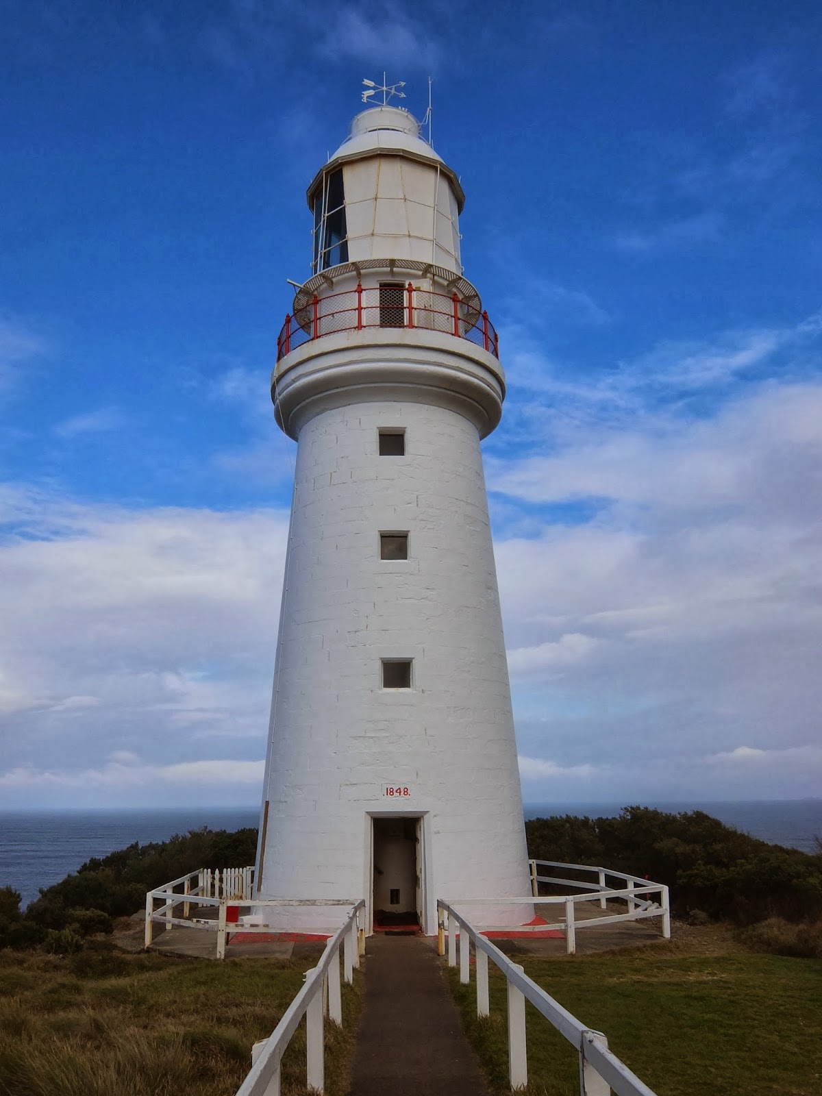
Down the road from the koalas was the Cape Otway Lighthouse. Beautiful views are to be had looking east towards Apollo Bay from the top of the lighthouse. It is regarded as the most significant lighthouse in Australia and it was the first sight of land for many immigrants who had been sailing for months from Europe. In operation since 1848, it is the oldest, surviving lighthouse in mainland Australia. There is a lovely cafe there as well as accommodation in the head light keeper's or the manager's houses. We had lunch at the cafe (scones with clotted cream and jam for me) and returned to the Twelve Apostles to see if the sky and sun would give us better shots this afternoon.


We also visited Gibson Steps, which is one stop before the Twelve Apostles, as we skipped it the day before. You take the Steps down to the beach, which has great views in both directions. I was proud of both Mom and Dad for climbing the steps. It was well worth it.


Another sign, although not as dramatic.

View from the cafe.
We also visited Gibson Steps, which is one stop before the Twelve Apostles, as we skipped it the day before. You take the Steps down to the beach, which has great views in both directions. I was proud of both Mom and Dad for climbing the steps. It was well worth it.

The beach at Gibson Steps

Our flight to Alice Springs was leaving early Wednesday morning, so the next day we had to drive back to Melbourne, where we had booked a hotel close to the airport. Our last morning in Apollo Bay I went for a run (so nice to run along a beach~ can't do that in Edmonton or Karratha) and then Gil and Gay took us to Cafe Nautigals. We had a wonderful time catching up. It turns out I couldn't have timed my visit better as they were leaving Apollo Bay at the beginning of August to caravan around Australia. I'm so glad I got to see them again and I wish them the best as they make their way around this beautiful country. After taking some photos on the beach, we headed off, this time going east, back to Melbourne. We stopped in Lorne for lunch and to see Erskine Falls, and then Torquay to see the sundial and Bells Beach, one of the most famous surf beaches in the world.


The final hour driving into Melbourne in rush hour traffic, something I haven't had to deal with since leaving Edmonton, was not much fun, but we made it. The next morning was even worse, as we had to drive to the airport, get gas/petrol and find the entrance to the parkade where the rental cars were kept all before 8am. There were five (6?) lanes of traffic going into the airport and no one, including me, had any idea what lane they had to be in. We did several laps, as Dad and I argued about how to get to the parkade without having an accident, but we finally made it and made our flight too. Next stop, Alice Springs and Uluru!
Erskine Falls
So, you might fall down a hole, slip on rocks,
a tree might fall on you, or a snake could bite you.
Why are we down here again?
The final hour driving into Melbourne in rush hour traffic, something I haven't had to deal with since leaving Edmonton, was not much fun, but we made it. The next morning was even worse, as we had to drive to the airport, get gas/petrol and find the entrance to the parkade where the rental cars were kept all before 8am. There were five (6?) lanes of traffic going into the airport and no one, including me, had any idea what lane they had to be in. We did several laps, as Dad and I argued about how to get to the parkade without having an accident, but we finally made it and made our flight too. Next stop, Alice Springs and Uluru!